Bar nearby Cantiere
Malta
Bar nearby Cantiere
Cantiere
Cospicua, Malta
contacts phone
:
+356 7743 5555
Latitude:
35.8834856
, Longitude:
14.5213847
larger map & directions
read more
nearest Bar
310 m
Del Borgo
San Duminku, Birgu
Bar
read more
347 m
old city pub
104 Triq San Lawrenz, Birgu
Bar
read more
349 m
Prince of Wales Own Band Club
Birgu
Bar
read more
364 m
BIRGI
97 Triq San Lawrenz, Birgu
Bar
read more
460 m
Vittoriosa F.C. Bar & Restaurant
Triq Desain, Birgu
Bar
read more
468 m
Destination Invictus
Triq San Pietru U San Pawl, L-Isla
Bar
read more
504 m
Ryans bar
Lbic, Birgu
Bar
read more
508 m
L' Angolo Di Vino
Tramuntana, Birgu
Bar
read more
540 m
Malta Pontoon E 5
Xatt Il - Forn, Birgu
Bar
read more
563 m
Don Berto Restaurant
Birgu Waterfront Il-Birgu
Bar
Restaurant
Food
Point of interest
Establishment
read more
713 m
Bocci club
Birgu
Bar
read more
838 m
Supernova Heights
Triq Marina, Il-Kalkara
Bar
read more
1.005 km
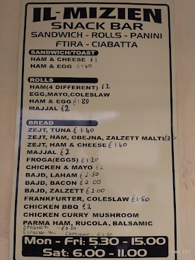
Il-Mizien Snack Bar
Kordin, Raħal Ġdid
Bar
read more
1.024 km
E. Imports & Services
Ent D Flt 2 Apart 25th Anniversary, Triq Luigi Pisani Malta, KKR1331, Kalkara
Bar
read more
1.417 km
The Crew Bar
Floriana
Bar
read more
1.658 km
Vino's Cafe Bar
19, Triq San Gwann, Il-Belt Valletta
Bar
read more
1.677 km
Il-Gażin Vilhena Band Club
14 St. Anne street Il-Furjana FRN
Bar
Point of interest
Establishment
read more
1.79 km
Charles Grech
10 Republic Street, Valletta
Bar
read more
1.843 km
Offbeat Music Bar
106 Merchants Street, Valletta
Bar
read more
1.855 km
The Rootz Bar
11 Strait Street, Valletta
Bar
read more
1.916 km
Alchemy Bar
93 Strait Street, Valletta
Bar
read more
1.951 km
Il Pup
Old Bakery Street, Il-Belt Valletta
Bar
read more
1.955 km
Alchemy Bar
Strait Street, Valletta
Bar
read more
2.071 km
Maori
Valletta
Bar
read more
2.518 km
Beans Café
3, 4 Ta' Xbiex Marina Road, Ta' Xbiex
Restaurant
Night club
Cafe
Bar
Store
Food
Point of interest
Establishment
read more
📑
all categories
Accounting
Airport
Amusement park
Aquarium
Art gallery
Atm
Bakery
Bank
Bar
Beauty salon
Bicycle store
Book store
Bowling alley
Bus station
Cafe
Campground
Car dealer
Car rental
Car repair
Car wash
Casino
Cemetery
Church
City hall
Clothing store
Colloquial area
Convenience store
Country
Courthouse
Dentist
Department store
Doctor
Electrician
Electronics store
Embassy
Establishment
Finance
Fire station
Florist
Food
Funeral home
Furniture store
Gas station
General contractor
Grocery or supermarket
Gym
Hair care
Hardware store
Health
Home goods store
Hospital
Insurance agency
Jewelry store
Laundry
Lawyer
Library
Liquor store
Local government office
Locality
Locksmith
Lodging
Meal delivery
Meal takeaway
Mosque
Movie rental
Movie theater
Moving company
Museum
Natural feature
Neighborhood
Night club
Painter
Park
Parking
Pet store
Pharmacy
Physiotherapist
Place of worship
Plumber
Point of interest
Police
Post office
Premise
Real estate agency
Restaurant
Route
Rv park, camping
School
Shoe store
Shopping mall
Spa
Stadium
Storage
Store
Subpremise
Supermarket
Synagogue
Taxi stand
Transit station
Travel agency
University
Veterinary care
Zoo
sublocality level 1
↑