Bar nearby Saint Lawrence Bar
Malta
Bar nearby Saint Lawrence Bar
Saint Lawrence Bar
Triq ta' Ċangura, San Lawrenz, MT Malta
contacts phone
:
+356
Latitude:
36.0552125
, Longitude:
14.2037314
larger map & directions
read more
nearest Bar
832 m
Massar Vinyards
Gharb
Bar
read more
2.647 km
Ta' Kercem Cafe Club
55, Pjazza San Girgor, Kercem
Bar
read more
2.656 km
Bar
Triq L Avukat Anton Calleja, Ta' Kerċem
Bar
read more
2.885 km
Greens Sports Bar & Grill
Wenzu Mintoff, Ta' Kerċem
Bar
read more
2.961 km
The Captain's Table
Gostra, Il-Munxar
Bar
read more
2.996 km
ANTOINETTE'S SNACK BAR
Munxar
Bar
read more
3.001 km
Talija Restaurant
Xlendi
Bar
read more
3.015 km
Mobydick Xlendi Complex & Restaurant
4 Marina street, Xlendi bay, Gozo
Bar
read more
3.035 km
St. Patrick's Hotel
Xatt ix-Xlendi, Munxar
Bar
read more
3.041 km
Zebbug Rovers Bar & Grill
Triq Mons Ġużeppi De Piro, Iż-Żebbuġ
Bar
read more
3.275 km
Fantasía Gozo
Mons Vella, Ir-Rabat Għawdex
Bar
read more
3.34 km
Coney Island Bar
13 Triq Sir Adrian Dingli, Ir-Rabat Għawdex
Bar
read more
3.397 km
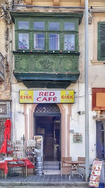
Red Cafe
24, Independence Square VCT 1023, Victoria
Bar
read more
3.418 km
Tepie's Coffee Bar
Triq is-Suq, Ir-Rabat Għawdex
Bar
read more
3.441 km
Ritz snack bar
140 VCT 1011, Triq ir-Repubblika, Victoria
Bar
read more
3.554 km
Glory Of England Bar
Victoria
Bar
read more
4.044 km
Flamingo
Pjazza President J.F. Kennedy, Ir-Rabat Għawdex
Bar
read more
4.649 km
Vinyard Restaurant
Triq L-Imġarr, Ir-Rabat Għawdex
Bar
read more
4.709 km
St.Margaret Pizzeria
23 St.Margaret Sqr. Gozo, Sannat
Bar
read more
4.719 km
Sannat Lions Football Club
21, Pjazza Santa Margerita, Sannat
Bar
read more
4.905 km
Ta Rosina
34 saguna street maltz gozo, Ta' Sannat
Bar
read more
5.021 km
Westend Bar Terrace
Triq L-Imġarr, Ix-Xewkija
Bar
read more
5.218 km
Kyra'sInn
Triq Il-Port, Iż-Żebbuġ
Bar
read more
5.219 km
Unwine'd
Triq Il-Port, Iż-Żebbuġ
Bar
read more
5.251 km
Traffic Light Bar
Triq Il-Qbajjar, Iż-Żebbuġ
Bar
read more
📑
all categories
Accounting
Airport
Amusement park
Aquarium
Art gallery
Atm
Bakery
Bank
Bar
Beauty salon
Bicycle store
Book store
Bowling alley
Bus station
Cafe
Campground
Car dealer
Car rental
Car repair
Car wash
Casino
Cemetery
Church
City hall
Clothing store
Colloquial area
Convenience store
Country
Courthouse
Dentist
Department store
Doctor
Electrician
Electronics store
Embassy
Establishment
Finance
Fire station
Florist
Food
Funeral home
Furniture store
Gas station
General contractor
Grocery or supermarket
Gym
Hair care
Hardware store
Health
Home goods store
Hospital
Insurance agency
Jewelry store
Laundry
Lawyer
Library
Liquor store
Local government office
Locality
Locksmith
Lodging
Meal delivery
Meal takeaway
Mosque
Movie rental
Movie theater
Moving company
Museum
Natural feature
Neighborhood
Night club
Painter
Park
Parking
Pet store
Pharmacy
Physiotherapist
Place of worship
Plumber
Point of interest
Police
Post office
Premise
Real estate agency
Restaurant
Route
Rv park, camping
School
Shoe store
Shopping mall
Spa
Stadium
Storage
Store
Subpremise
Supermarket
Synagogue
Taxi stand
Transit station
Travel agency
University
Veterinary care
Zoo
sublocality level 1
↑