Cafe nearby L-Arlogg Cafe & Bistro
Malta
Cafe nearby L-Arlogg Cafe & Bistro
L-Arlogg Cafe & Bistro
Triq P. Boffa, Il-Birgu, MT Malta
contacts phone
:
+356 9995 7997
website:
m.facebook.com
Latitude:
35.8881374
, Longitude:
14.5222025
larger map & directions
read more
nearest Cafe
326 m
Cafe Riche
Malta
Cafe
read more
329 m
Senglea Waterfront
Senglea
Cafe
read more
335 m
Chill Cafe and Restaurant
Malta
Cafe
read more
530 m
Caffe Pascucci
Fuq San L-Inkurunazzjoni, Bormla
Cafe
read more
660 m
Nuovo Café San Giorgio
Piazza Paolino Vassallo, Bormla
Cafe
read more
710 m
Cafe Rouge
Fuq San L-Inkurunazzjoni, Bormla
Cafe
read more
776 m
cafe du brazil
Cospicua
Cafe
read more
1.206 km
Upper Barrakka Kiosk
Valletta
Cafe
read more
1.25 km
Caffe Pascucci
Valletta
Cafe
read more
1.25 km
Caffe Pascucci
Castille Street, Valletta
Cafe
read more
1.269 km
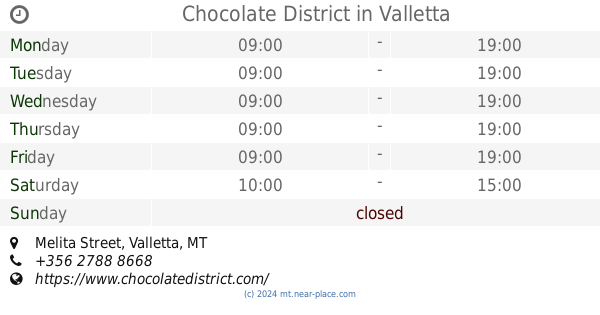
Chocolate District
Triq Melita, Valletta
Cafe
read more
1.269 km
Chocolate District
Melita Street, Valletta
Cafe
Store
Food
Point of interest
Establishment
read more
1.29 km
Dolceria Croce Bonaci
24D, San Gwann, Valletta, Malta
Cafe
read more
1.315 km
No. 43
43, Triq Il-Merkanti, Il-Belt Valletta
Cafe
read more
1.37 km
Gambrinus
158, Triq Melita, Il-Belt Valletta
Cafe
read more
1.37 km
Gambrinus
158 Melita Street, Valletta
Cafe
Food
Point of interest
Establishment
read more
1.392 km
Kantina Café - Wine
Valletta
Cafe
read more
1.414 km
Kingsway Bar & Café
57 Republic Street, Valletta
Cafe
read more
1.419 km
The Ladybird Gourmet Store
54 Republic Street, Valletta
Cafe
read more
1.424 km
Caffe Cordina
244 Republic, Il-Belt Valletta
Cafe
read more
1.466 km
StrEat Cafe
46, Old Theatre Street, Valletta
Cafe
read more
1.491 km
The Corner
Strait Street, Valletta
Cafe
read more
1.512 km
Nate's
Old Theatre Street, Valletta
Cafe
read more
1.563 km
Café Phoenicia
The Mall, Il-Furjana
Cafe
read more
1.587 km
Breakcafe Malta
71 Triq Il- Karmelitani, Il-Fgura
Cafe
read more
📑
all categories
Accounting
Airport
Amusement park
Aquarium
Art gallery
Atm
Bakery
Bank
Bar
Beauty salon
Bicycle store
Book store
Bowling alley
Bus station
Cafe
Campground
Car dealer
Car rental
Car repair
Car wash
Casino
Cemetery
Church
City hall
Clothing store
Colloquial area
Convenience store
Country
Courthouse
Dentist
Department store
Doctor
Electrician
Electronics store
Embassy
Establishment
Finance
Fire station
Florist
Food
Funeral home
Furniture store
Gas station
General contractor
Grocery or supermarket
Gym
Hair care
Hardware store
Health
Home goods store
Hospital
Insurance agency
Jewelry store
Laundry
Lawyer
Library
Liquor store
Local government office
Locality
Locksmith
Lodging
Meal delivery
Meal takeaway
Mosque
Movie rental
Movie theater
Moving company
Museum
Natural feature
Neighborhood
Night club
Painter
Park
Parking
Pet store
Pharmacy
Physiotherapist
Place of worship
Plumber
Point of interest
Police
Post office
Premise
Real estate agency
Restaurant
Route
Rv park, camping
School
Shoe store
Shopping mall
Spa
Stadium
Storage
Store
Subpremise
Supermarket
Synagogue
Taxi stand
Transit station
Travel agency
University
Veterinary care
Zoo
sublocality level 1
↑