Restaurant nearby Sergio's Rooftop
Malta
Restaurant nearby Sergio's Rooftop
Sergio's Rooftop
Triq taż-Żwejt, San Ġwann, MT Malta
contacts phone
:
+356 2137 7525
Latitude:
35.9058511
, Longitude:
14.4690992
larger map & directions
read more
nearest Restaurant
16 m
Lo Spuntino at the Rooftop
Triq iz-Zwejt, San Gwann
Restaurant
read more
466 m
Zenzero
San Gwann
Restaurant
read more
481 m
A La Turca
Triq Tal Balal, San Ġwann
Restaurant
read more
512 m
Giulia Restobar
Triq id-Disgħa ta' Frar 1799, San Ġwann
Restaurant
read more
642 m
Zarzarell
Birkirkara
Restaurant
read more
689 m
Jon's Pad
Jannara, Birkirkara
Restaurant
read more
706 m
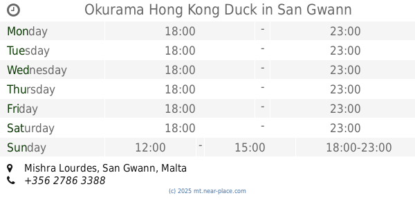
Okurama Hong Kong Duck
Mishra Lourdes, San Gwann
Restaurant
read more
762 m
Il Cortile - Wine & Dine
45 Triq Hal-Gharghur, San Ġwann
Restaurant
read more
777 m
Gabe's pastizzi and take away 24/7
39 Sqaq Karla, Birkirkara
Restaurant
read more
794 m
The Sugar Kitchen
Il-Kappella, San Ġwann
Restaurant
read more
813 m
Hoi Fan
Triq San Guzepp, San Ġwann
Restaurant
read more
826 m
The PlayingField
Triq John Borg, Birkirkara
Restaurant
read more
891 m
Sphinx
San Gwann
Restaurant
read more
903 m
Bahia restaurant
Msida
Restaurant
read more
959 m
AFIYET OLSUN HOUSE OF KEBAB
NAXXAR ROAD, San Gwann
Restaurant
read more
1.034 km
Coral Cafe
Triq in Naxxar, San Ġwann
Restaurant
read more
1.204 km
B'Kara Kebab
BKR1270, Triq L-Isqof Labini, Birkirkara
Restaurant
read more
1.24 km
Andrew's Snack Bar
14/15, Triq Sant' Antnin, Birkirkara
Restaurant
read more
1.264 km
Restaurants In Malta
Naxxar Road, Birkirkara
Restaurant
read more
1.302 km
Dias Pizzeria
152 Valley Road, Birkirkara
Restaurant
read more
1.35 km
Vidas Grill
96 J. Zammit, Birkirkara
Restaurant
read more
1.394 km
Sensations Wine Bar Pizzeria & Grill
Valley Road, Birkirkara
Restaurant
read more
1.506 km
Matilds's Cafe & Bistro
Judge Paolo Debono Street, Msida
Restaurant
read more
2.215 km
Solo Pizza
ix-Xatt Ta' Xbiex, L-Imsida
Restaurant
read more
2.339 km
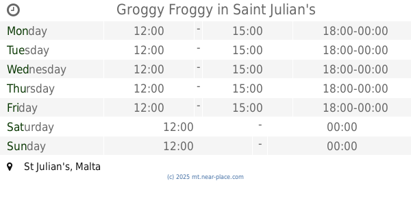
Groggy Froggy
Saint Julian's
Restaurant
read more
📑
all categories
Accounting
Airport
Amusement park
Aquarium
Art gallery
Atm
Bakery
Bank
Bar
Beauty salon
Bicycle store
Book store
Bowling alley
Bus station
Cafe
Campground
Car dealer
Car rental
Car repair
Car wash
Casino
Cemetery
Church
City hall
Clothing store
Colloquial area
Convenience store
Country
Courthouse
Dentist
Department store
Doctor
Electrician
Electronics store
Embassy
Establishment
Finance
Fire station
Florist
Food
Funeral home
Furniture store
Gas station
General contractor
Grocery or supermarket
Gym
Hair care
Hardware store
Health
Home goods store
Hospital
Insurance agency
Jewelry store
Laundry
Lawyer
Library
Liquor store
Local government office
Locality
Locksmith
Lodging
Meal delivery
Meal takeaway
Mosque
Movie rental
Movie theater
Moving company
Museum
Natural feature
Neighborhood
Night club
Painter
Park
Parking
Pet store
Pharmacy
Physiotherapist
Place of worship
Plumber
Point of interest
Police
Post office
Premise
Real estate agency
Restaurant
Route
Rv park, camping
School
Shoe store
Shopping mall
Spa
Stadium
Storage
Store
Subpremise
Supermarket
Synagogue
Taxi stand
Transit station
Travel agency
University
Veterinary care
Zoo
sublocality level 1
↑