School nearby English School
Malta
School nearby English School
English School
Triq Maria Teresa Spinelli, Il-Gżira Malta
contacts phone
:
+356
Latitude:
35.9030196
, Longitude:
14.4868144
read more
nearest School
68 m
Institute of Physical Education and Sport
Msida
School
read more
186 m
St Monica School Gzira
Gzira
School
read more
225 m
Institute of Space Sciences and Astronomy
Msida
School
read more
271 m
St. Francis School
Ferris, L-Imsida
School
read more
353 m
Faculty of Education
Msida
School
read more
353 m
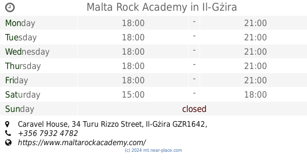
Malta Rock Academy
Caravel House, 34 Turu Rizzo Street, Il-Gżira
School
read more
378 m
Faculty of Arts
Old Humanities Building, Msida
School
read more
382 m
Fleurette School of Montessori
185 Road Kappara SGN 4417, Tas-Sliema
School
read more
397 m
Gzira Primary School
Gzira
School
read more
503 m
St. Clare College Boy's Secondary School, Turu Colombo Square
Gzira
School
read more
507 m
Visual Arts Department UOM
Msida
School
read more
510 m
St Clare College
Gzira
School
read more
534 m
The Playhouse
Gzira
School
read more
566 m
Margot's Nursery
Misram Turu Colombo, 13 gzira
School
read more
684 m
YogaAtHarmony
156, Harmony, Conception Street,, Msida
School
read more
709 m
VegasMaster
Quantum House, 75 Triq l-Abate Rigord, Ta' Xbiex
School
read more
729 m
Giggles Nursery
61 Triq il-Gzira, Il-Gżira
School
read more
925 m
Sacred Heart School Malta
Triq Il-Qalb Imqaddsa
School
read more
925 m
Sacred Heart School
Triq Il-Qalb Imqaddsa
School
read more
959 m
Kid's Haven Child Care Centre
Sqaq Tomna c/w Mudest Sapiano Street, San Ġwann
School
read more
1.062 km
The Malta Institute of Accountants
Level 1, Tower Business Centre, Tower Street, Swatar, BKR, 4013, Msida
School
read more
1.066 km
The Nursery School Child Day Care Club
Triq San Albert, Il-Gżira
School
read more
1.081 km
eused dihei
Sliema
School
read more
1.094 km
Peekaboo Early Learning & Child care Centre
Pieta
School
read more
1.153 km
MaltaVista International Education
Triq San Andrija
School
read more
📑
all categories
Accounting
Airport
Amusement park
Aquarium
Art gallery
Atm
Bakery
Bank
Bar
Beauty salon
Bicycle store
Book store
Bowling alley
Bus station
Cafe
Campground
Car dealer
Car rental
Car repair
Car wash
Casino
Cemetery
Church
City hall
Clothing store
Colloquial area
Convenience store
Country
Courthouse
Dentist
Department store
Doctor
Electrician
Electronics store
Embassy
Establishment
Finance
Fire station
Florist
Food
Funeral home
Furniture store
Gas station
General contractor
Grocery or supermarket
Gym
Hair care
Hardware store
Health
Home goods store
Hospital
Insurance agency
Jewelry store
Laundry
Lawyer
Library
Liquor store
Local government office
Locality
Locksmith
Lodging
Meal delivery
Meal takeaway
Mosque
Movie rental
Movie theater
Moving company
Museum
Natural feature
Neighborhood
Night club
Painter
Park
Parking
Pet store
Pharmacy
Physiotherapist
Place of worship
Plumber
Point of interest
Police
Post office
Premise
Real estate agency
Restaurant
Route
Rv park, camping
School
Shoe store
Shopping mall
Spa
Stadium
Storage
Store
Subpremise
Supermarket
Synagogue
Taxi stand
Transit station
Travel agency
University
Veterinary care
Zoo
sublocality level 1
↑