School nearby Kirkop middle school
Malta
School nearby Kirkop middle school
Kirkop middle school
Triq Ħal Safi, Ħal Kirkop Malta
contacts phone
:
+356
Latitude:
35.8391556
, Longitude:
14.4845114
read more
nearest School
102 m
St. Benedict's College - Secondary School
Triq San Ġwann, Ħal Kirkop
School
read more
129 m
St. Benedict's College - Middle School
Hal Kirkop
School
read more
182 m
Kirkop Primary School
Triq San Benedittu, Ħal Kirkop
School
read more
592 m
MusicalMe
Triq In-Nassaba, Ħal Safi
School
read more
592 m
Toddler music
Triq In-Nassaba, Ħal Safi
School
read more
1.284 km
Skola Primarja Zurrieq
Iż-Żurrieq
School
read more
1.325 km
Zurrieq Primary School
Triq Dun Ġużepp Zammit, Iż-Żurrieq
School
read more
1.601 km
Gilbert J Zahra
46 Triq Guzeppi Mattew Callus, Iż-Żurrieq
School
read more
1.667 km
EF Education First - Airport Office
Malta International Airport
School
read more
1.755 km
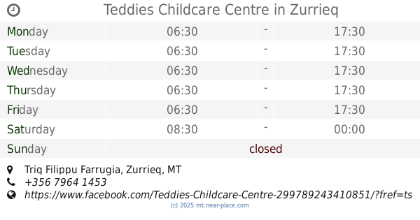
Teddies Childcare Centre
12, Triq Filippu Farrugia, Zurrieq
School
read more
1.808 km
Primary School Mqabba
Mqabba
School
read more
1.834 km
Kulleġġ San Benedittu - Skola Primarja Mqabba
L-Imqabba
School
read more
1.973 km
Bitha Tal Skola Primary
Zurrieq
School
read more
1.989 km
SDC Boys Museum
Gudja
School
read more
2.106 km
Luqa primary school, st Ignatius college Luqa
Luqa
School
read more
2.145 km
St Jeanne Antide
Gudja
School
read more
2.357 km
Malta School of Flying
Malta International Airport, Security Gate 1, Ħal Luqa
School
read more
2.973 km
Primary School Ghaxaq
92 Triq Il Gudja, Ħal Għaxaq
School
read more
2.973 km
Police Force Academy
Siggiewi
School
read more
3.002 km
St Thomas More College, Girls’ Secondary School
Santa Luċija
School
read more
3.248 km
All C'ees Child Care Centre
Begonja, Santa Luċija
School
read more
3.565 km
St. Thomas More Middle School Tarxien
Tarxien
School
read more
3.611 km
Thomas More Middle School
Triq Moyra Mintoff, Ħal Tarxien
School
read more
3.617 km
Lookstar Dancers
Tarxien
School
read more
4.07 km
Rainbow Kids Child Care Centre
Leonardu Abela, Ħal Tarxien
School
read more
📑
all categories
Accounting
Airport
Amusement park
Aquarium
Art gallery
Atm
Bakery
Bank
Bar
Beauty salon
Bicycle store
Book store
Bowling alley
Bus station
Cafe
Campground
Car dealer
Car rental
Car repair
Car wash
Casino
Cemetery
Church
City hall
Clothing store
Colloquial area
Convenience store
Country
Courthouse
Dentist
Department store
Doctor
Electrician
Electronics store
Embassy
Establishment
Finance
Fire station
Florist
Food
Funeral home
Furniture store
Gas station
General contractor
Grocery or supermarket
Gym
Hair care
Hardware store
Health
Home goods store
Hospital
Insurance agency
Jewelry store
Laundry
Lawyer
Library
Liquor store
Local government office
Locality
Locksmith
Lodging
Meal delivery
Meal takeaway
Mosque
Movie rental
Movie theater
Moving company
Museum
Natural feature
Neighborhood
Night club
Painter
Park
Parking
Pet store
Pharmacy
Physiotherapist
Place of worship
Plumber
Point of interest
Police
Post office
Premise
Real estate agency
Restaurant
Route
Rv park, camping
School
Shoe store
Shopping mall
Spa
Stadium
Storage
Store
Subpremise
Supermarket
Synagogue
Taxi stand
Transit station
Travel agency
University
Veterinary care
Zoo
sublocality level 1
↑